Follow


Follow us with Map Share on Delorme In-Reach:
https://share.delorme.com/SummerPlace

Wednesday, November 2, 2016

Ensenada


Avalon to Ensenada      October 30, 2016
A cruise ship arrived last night and is anchored outside the harbor. 
We are leaving Avalon this morning for an overnighter to Ensenada.  The wind is light and there are some sprinkles.  Most of the inclimate weather is behind us to the north. 
There is a lot more naval activity in this area.  We see multiple vessels and aircraft performing maneuvers.  There is a relatively small aircraft carrier with harrier jets taking off and landing.
 As night comes there is light traffic.  The only real worry is a Mexican fishing vessel that is on the radar but only visible by the dim port navigation light as it passes a half mile off  the port side.  Bioluminescence is visible from the prop and also from dolphins as they swim up to the boat and away.
October 31, 2016
Arriving this morning in Ensenada, we are greeted at the dock by Carlos, the dock master, who helps catch our lines and escorts us through the gates to the marina office. 

Jose in the office at Baja Naval helps us fill out and organize our forms for immigration.  Immigration is a bit of a walk, but not as far as it would be from the other marinas in Ensenada.  The immigration process is long and tedious, but thankfully most of where you need to go is located in one small building.  First you bring documents and copies of documents to immigration and fill out the FMM form.  Next you get in line at the bank to pay immigration fees ($44.00 US cash only), and then go back to immigration to have your documents and passports stamped.   At this point you need to take a number for the harbor master.  After a couple hours there was some noticeable movement in the line.  The harbor master stamps your forms again and then you go back to the bank to pay a fee ($15.00 US cash only).  Back to the harbor master and then back to the bank to pay for the temporary import permit which allows you to bring your boat engine into the country.  The TIP is good for ten years, but if you don’t cancel it when you sell the boat, then the next owner will not be able to bring the boat back into Mexico.   The cost of the TIP is $60.00 dollars US, cash.  This time we did not have to give the bank a copy of our passport as we did with the other two payments.  The bank actually issues the TIP, but you need to stop at the customs office to process that information.  Because there are forms to file before leaving BC, Baja California, as well, we did that paperwork too.  It is such a feeling of relief when it is all complete.  Words of advice for this process: expect to wait, bring cash. Also have originals and many copies of passports, boat documentation, boat insurance, and your engine serial number for the TIP.  On the walk back to the marina we stopped at a fishing store and purchased two fishing permits, $40.00 dollars each for 12 months.  This is one of the requirements for having fishing supplies on the boat.

November 1, 2016
The one issue we would like to resolve before departing Ensenada is our communication system.   It has taken a couple calls to IRIDIUM to get the SAT phone to work.  We would like to set up our Email through the SAT phone as well, since the single side band radio has been so unreliable ever since the rigging was updated.  
We did hike into town and find a familiar grocery, so we were able to stock up on a few supplies.  We have to remind ourselves to buy only what we can carry.  There are probably many more groceries than we realize, but our Spanish is very limited.  We need to work on minimizing our language barrier.  I think the prices are less than in the states.  Roughly I would day there are 90 pesos to 5 dollars. 
November 2, 2016, Day of the Dead
A working knowledge of Spanish would have really come in handy today.    First thing this morning, we headed for Coral Marina where there is a fuel dock. The price was under 3 dollars per gallon which beats the last price we saw in the U.S. 

Our other adventure was getting cell phone service from Mexico.  It turned out neither of our phones would accept a different SIM card so we purchased a new phone.  After the phone purchase when went to an OXXO store which is like a corner convenience store, to purchase the plan. 

In the evening we walked around the waterfront and were treated to a fountain and light display.


Sunday, October 30, 2016

Channel Islands


VENTURA TO SANTA CRUZ ISLAND      October 21, 2016


Crossing the Santa Barbara Channel, our destination is Santa Cruz Island.


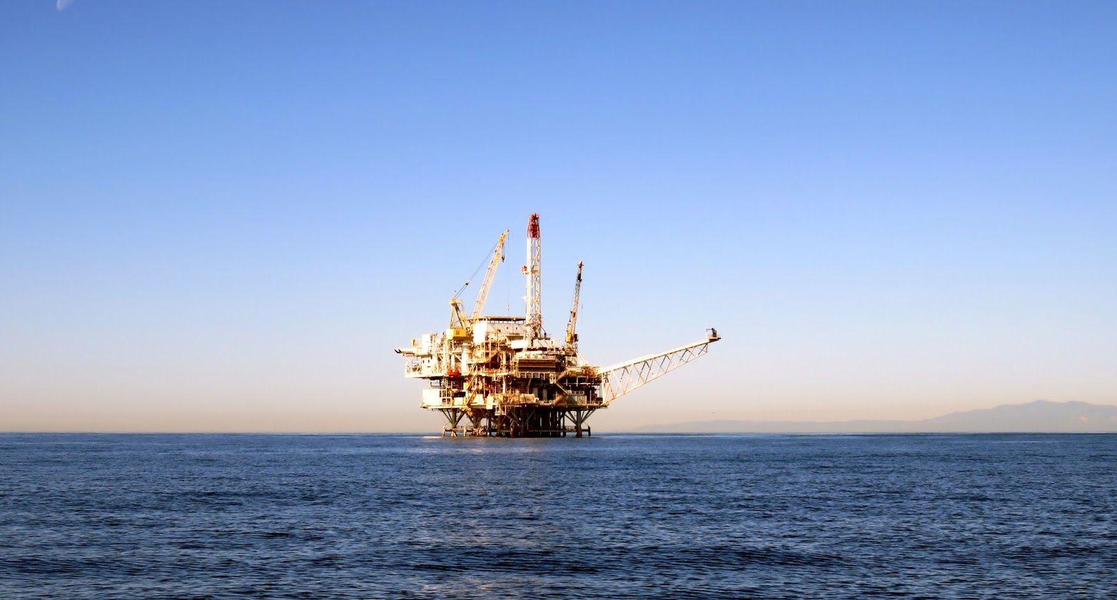
We pass near one of the offshore oil rigs that dot the channel.


In Chinese Harbor on the north shore, there is really no protection from the westerly swells and the wakes of passing ships.  It is a bumpy night even though we deployed the flopper stoppers, hanging from the whisker pole on the port and the boom on the starboard.

October 22, 2016

Departure today waits until the fog lifts.  The anchor which held fast comes up well and is clean.  We are heading around the island counter clockwise to look for an anchorage with more protection.  Visibility becomes quite limited as we catch up to the fog.  Thank goodness for radar.


As we round the west side of Santa Cruz Island, the fog is kept at bay by the wind.  The sun shines brightly for the first time today. 


As we continue along the south shoreline, the wind decreases and the seas calm.  There isn’t a lot of vegetation to see from this distance, but the striations of rock are beautiful and remind me of a stained glass mural. 


Our final destination is Coches Prietos.  We tuck in between five boats already here and drop the anchor in 30 feet of water. The surf is pounding the rocks near the cliff 120 yards from our stern. 

October 23. 2016

Our first night is not too bad as far as motion.  We consider getting the dinghy out and going ashore, but the surf seems rougher today.  We're not sure we want to attempt our first surf landing under these conditions. 


As the day turns to dusk, the fishing fleet arrives and one by one they anchor outside our area. 
SANTA CRUZ TO SANTA CATALINA ISLAND     October 24, 2016


 Our second night is worse for boat motion.  I am ready to depart when the alarm clock sounds at 3 AM.  Once again the anchor comes up without a problem and cleanly as far as I can tell in the blackness of night.  There is a break in the lights from the fishing fleet which gives us a clear path for our route to Santa Catalina Island.  While motoring, we see flashes of light in the distance.  The weather report calls for morning thunder storms along the coast. 


The wind is 2-5 knots, so not even worth a sail.


A few cargo vessels pass by.


As Santa Catalina appears on the horizon we alter coarse for the south side and make plans to pick up a mooring buoy in Catalina Harbor. 


At the entrance to the harbor is this interesting vessel moored on the coast guard’s buoy. 


There is plenty of room in the mooring field.  The area is protected from waves. When the wind picks up, blowing from across the isthmus, it doesn’t seem to have much fetch.  The scenery at first appears a bit bleak.  We appreciate the subtle beauty of our surroundings. 


It appears like mostly locals stay here this time of year.  One of the more interesting locals perched on our neighbor’s mast for some time.

October 25, 2016

Staying in Cat Harbor for another day, we get off the boat for the first time.  Once on shore there is a short walk along a dirt road bordered by prickly cactus and an occasional eucalyptus tree.


On the other side of the isthmus is Two Harbors.  Although quite minimal, this is definitely the tourist side.  There is a store, information center, dive and recreational center, pier with fuel dock, a restaurant or two, AND flush toilets.  The water is clearer on this side with more movement.  We buy a couple beverages and watch the pelicans diving to catch a meal before hiking back to Cat Harbor.

 October 26, 2016

Leaving Cat Harbor with the bow stern mooring buoy system is very simple.  We just let go the stern, allow the line to settle, put the float back in the water and let loose the bow.  As we drift away from the buoy, Brad engages the engine and we head for the ocean.  As we travel along the south side of Catalina Island the wind is strong enough to sail for a whole 21 minutes. 


Our destination today is Avalon.  When one thinks of Catalina Island, they usually picture Avalon with the classic circular casino, mooring field, and homes clinging to the surrounding cliffs. 


As we approach the harbor, we are greeted by the harbor patrol boat, which takes our information, escorts us to a buoy and assists us in hooking up.  The captain comes on board to deposit the yellow tablets in our septic system to ensure no leakage in this no discharge zone.  You must pay the moorage fee at this time. 
Who can resist leaving the boat in this picturesque and touristy town.  The patrol boats and taxi boats ferry people to and from shore for a fee.   We are hardly settled before we catch a ride. 
It is off season, so the crowd is minimal.  There is a lovely walkway along the shore out to the casino which is now used as a theater.

Just off the casino is a diving sight with map and compass headings.  The water visibility is good. 


On the walk back we stop at a delightful restaurant with a large sculpture of a double burger out front.  The staff is very pleasant, the food is good, and the view overlooking the water can’t be beat. 
Forty three dollars will get you a golf cart for an hour which allows us to cover more territory.   After a few jogs through town we are heading along the shore and up the cliff for a dizzying view of the harbor.  We wind our way through the eucalyptus trees and homes that dot the hillside.  Keeping to the marked tour, we follow the map with a few stops for photo ops. 

Brad has been communicating with the marina in Ensenada to check on availability and entrance requirements.  We may not be allowed entrance if the permit (TIP) taken out by the prior owner of this vessel is still in effect.  So while we are a waiting to find this out, we have decided to take advantage of the off season rates in Avalon, which are pay for two nights and get five nights free.

October 27, 2016

A good night’s sleep with only mild bouncing from passing wakes and swells.  Having decided to stay awhile, it’s time to put the dingy in the water.  We are using one of the halyards to pick it up off the deck.  Another halyard is fastened to the hanging harness which is already attached to points inside the dingy.  After the dingy is turned over, Brad puts the two horse motor on before lowering into the water.  A real energy saver is the heavy weight drill with the wench handle bit we use to do all the lifting. 


October 28, 2016
Another excursion into town today, this time to do the laundry.  At the laundry which is a good walk into town and down a side alley, we run into the couple from the boat, the Redwood Coast who we met at Coches Prietos and then saw again at Catalina Harbor.

October 29, 2016


 The dingy dock is crowded.


Avalon has a wonderful miniature golf course.

 
Each hole is designed to match a fun fact about the island.


The carillon on the hillside above the mooring, chimes every quarter hour.  Saturday evening, in addition to the usual chime it played several familiar songs. 

Tuesday, September 20, 2016

Coos Bay to Ventura California

Ready to leave Charleston, OR


Cape Arago Lighthouse


Beautiful sunset


25 to 30 knot winds

Sailing at 7.6 knots


Susan at the helm
Another sunset
Ventura Isle marina, slip K22, we made it.


Saturday, September 10, 2016

Charelston to Ventura


Sunday, September 4, 2016 - Labor Day Weekend
The Grib file looks satisfactory, so we are putting last minute provisions on Summer Place.  We are messaging our plans to work, church, and friends, and calling family.  Sometimes you have to put your responsibilities on hold and just take a leap of faith.  This is the first step to a very long awaited journey. 
Departing Charleston at 10 AM, it is a beautiful day.  The sun is shining and there is a mild breeze out of the northwest.  Brad and I will take shifts in the cockpit.  Brad will take from 20:00 to 01:00 and I am on from 01:00 to 06:00.
Out in the ocean we set the sails and turn off the engine.  The wind is picking up gradually.  The sails are held out to port.  The genoa is held with the whisker pole and the main is secured by the preventer. Before dusk we bring in the main to the second reef. 
Visibility is good as the sun sets on the horizon.  The lights in the cabin and on the instruments are switched to red and dimmed for better night vision.  The radar is running. When I emerge from the cabin for my watch, the Big Dipper is framed perfectly in the companionway.  The stars are bright and guide us as we make way through the first night.  The wind is consistently 20 knots now giving us a steady SOG at 7 knots.  There is just one AIS target about 3 miles off the port.  It is a cargo ship illuminated by lights. 
Monday morning, the wind is picking up, 25-30 knots.  Swells are steep from the stern.  From my vantage point they look taller than the life lines. There is a bit of rocking from side to side.  Sitting on the sole after I fly across the boat from the galley to the navigation  station (about six feet), I consider the bruises that will soon come and remind myself to always stay braced when under way.
Monday night the wind diminishes to 15 knots for a while.  As morning approaches the wind has picked up to 30 knots and our SOG is greater than 10.  It feels like we are flying.  I rouse Brad on deck to help manage the genoas’ 3 sheets and furling line.  It’s time to lessen our sail. 
The sea is rough all day.  The wind is aft requiring us to adjust coarse a bit to keep from back winding the mainsail.  The preventer is keeping us from an accidental jibe. 
It is overcast with a distant fog bank all around.  The solar panels haven’t kept the batteries charged so we run the generator for a while.   Brad reports seeing a Carnival Cruise Ship and a Cargo Vessel on his watch.  All I see are waves with whitecaps which I imagine to be all sorts of things, including a submarine.  
Before the sun sets, which is not visible, we bring in the Genoa to the 2nd reef and put the main away.  This arrangement allows us to manage the sail from the cockpit overnight if necessary.  The wind has backed off to 22 knots.  We have traveled 300 miles and have just 400 more to go!
I Wake up that third night to the sound of wind and waves and the creaking of the boat.  I assist Brad as we put away the little bit of genoa that was still exposed.  Our three day sail down the coast is over and we are now a motor boat, at least for the next 7 hours. 
Over the course of the morning shift, the wind diminishes from 35 to 20 knots.  The sea is still rough.  There is sunshine with clear skies.   We spot a pod of whales feeding off the coast of San Francisco.  407 miles logged now. 
The wind is starting to die off as we turn east with the lay of the land.  The sails are flogging, so time to become a motorboat again.  A pleasant day turns to night with 6-15 knots on the bow.  The fog has come in so we are relying on the radar.  Not much contact until early morning when two targets appear on the AIS.  The first target is about 2 miles off, going our speed.  We never see it with our eyes.  It turns out to be a 42 ft. sailboat.  The second target is approaching faster at 19 knots and will be closer.  As AIS information becomes available, we know the second target is a Cargo Vessel.  We turn to port and hail the vessel to make them aware of our position and find out their intensions.  After they pass, we turn back to coarse.
Day breaks Thursday morning to overcast skies.  By mid-day it is a warm 83 degrees in the cockpit with the canvas open.  We have 3 knots of breeze and the water is like old glass, smooth and wavy.
The further south we travel the more marine life we observe.  On my watch I slowed the engine as a pod of feeding orcas come close to the vessel.  We see dolphins jumping and splashing.
On the fifth and last night at sea, we are approaching the off shore oil rigs.  When I awake for my watch, we are between the brightly lit rigs mostly to the port and cargo ships in the channel on the starboard.
We approach Ventura at 10 A.M. Friday morning.  This leg of our journey is complete.  It has been 120 hours of continuous sailing and motoring.  Summer Place will stay docked at Ventura Isle Marina until mid October when it is time to continue our voyage south.